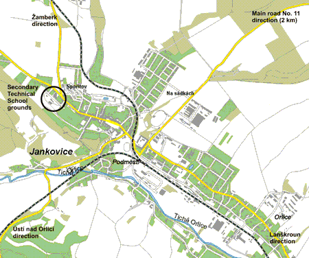
The location and surrounded area of Secondary Technical School
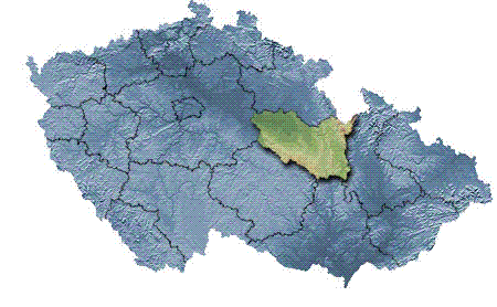
Pardubice region
 |
 The surface area of Pardubice region is
4519 km2 and it is
populated with 507 thousand people. The surface area of Pardubice region is
4519 km2 and it is
populated with 507 thousand people.In this region there are 32 towns and Letohrad, where Secondary Technical School can be found, is situated in its northeast part. |
The location of Pardubice region in the Czech Republic
Letohrad
For more information see www.mu.letohrad.cz
Letohrad outskirts
Only a few kilometres away from Letohrad, glamorous dam Pastviny, which is
suitable for summer holidays, was built on the river Divoká Orlice. Over 800-year-old
Vejda´s lime trees with stem perimeter about 1220 cm can be found nearby.
Close to the dam, Zemská brána, a place where Divoká Orlice is striking its way
through the rocks from Poland to the Czech Republic, is situated.
Jablonné nad Orlicí (town) with the picturesque square can be found near
Letohrad.
The viewpoint of the mountain range is Suchý Vrch (995 m) with the view-tower
and chalet. In winter the area of Suchý Vrch and Buková Hora (mountains) is
decussated with ski tracks. The well-known centre of down hill skiing, Čenkovice,
is nearby.
Military fortresses, which were built in 30s for defensive purposes, create
other interesting tourist attractions. Artillery fortress Bouda, westward from
Suchý Vrch, is most frequently visited.
Village Helvíkovice near Žamberk is reminded as a place of birth of Prokop
Diviš, the inventor of the lightning rod. The tourists are welcomed to take a
look round his house and see his famous invention.
Town Králíky with its fabulous monastery attracts the tourists as well.
Our school
The official name of our school is Secondary Technical School and Secondary
Training School in Letohrad.
On 1st July 2000 two schools mentioned above were united into one organization
unit. Nowadays, they create one institution, which has one headmaster and two
deputy headmasters who are directly responsible to the headmaster for extra
duties of both schools.
Secondary Training School specializes in engineering and electrotechnic fields.
The following details are linked only with Secondary Technical School.
The grounds of Secondary Technical School consist of: school building, two
boarding houses, school cafeteria, gymnasium and outdoor sport grounds. The
whole complex of buildings is directly linked to the surrounding charming
countryside.
The grounds of our school in detail can be seen in enclosed photographs.
The location of Secondary Technical School
The main access roads to Letohrad and the position of Secondary Technical School are marked on the map below.